The Hudson Valley is blessed in many ways. Perhaps the greatest asset for locals and visitors is its full array of seasonal changes. The region's wide variety of deciduous trees makes fall particularly enticing for leaf peeping visitors. What better way is there to view fall foliage than getting up close and personal with our tree friends and taking a hike on our public lands? The following are three popular local hikes offering spectacular fall foliage views throughout the Hudson Valley.
Beacon Mountain
Difficulty: Moderate
Total Mileage: 3.8
Elevation Gain: 1,500 feet
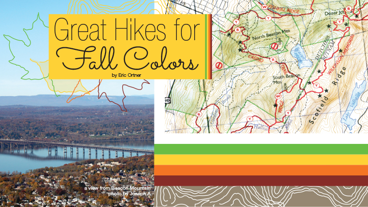
Beacon Mountain has been an important observation point in the Hudson Highlands since the Revolutionary War. The mountain's southern peak is the highest point in the Hudson Highlands. Due to its height, it served the Colonial forces as a lookout to watch for British troop movements along the Hudson River. In fact, Mount Beacon and the city below gain their namesake from the signal fires that were lit atop the mountain's summit when Redcoats were spotted. Today, fires are prohibited on the mountain. However, a newly restored fire tower sits atop the summit, offering panoramic views of the Hudson River Valley. On a clear day, you can even see the silhouette of the Manhattan skyline to the south from the tower. This makes Beacon a very popular location during peak foliage, and the parking lot can fill up quickly on the weekends. Visitors are advised to arrive early for the best parking.
Beacon Mountain is most easily reached from the parking area at Mount Beacon Park on Route 9D, just inside the Beacon City limits. From the parking area, the trail leads southeast along a flat gravel road for a short distance before it reaches a long set of metal stairs. To the right, you will notice the rusting remains of the Beacon Incline Railway, which once carried guests to Beacon Casino. At the top of the stairs, the red trail veers left and begins the .8 mile ascent towards the former terminus of the railway. The red trail follows a long series of switchbacks, at times steeply, in this section. The popularity of this trail is evident through the amount of loose scree that has resulted from overuse and erosion. Staying on the trail and not taking short cuts to avoid the switchbacks will help to reduce further erosion and also maintain the tree's root systems. As you breathe heavily forging your way forward, don't forget to stop and examine a few of the colorful leaves that have fallen from the magnificent trees that surround you.
Soon you will pass the junction of a yellow trail on your left. You should stay to the right, and continue to follow the red trail. There are a few other unmarked trails leading left as well. These are the remains of the Dutchess Ski Area, which operated from 1967 until 1975. You may also notice some concrete blocks along the trail that were the base of the ski lifts. After what seems like an eternity, the trail finally levels out, and you find yourself standing on the remains of the Beacon Casino.
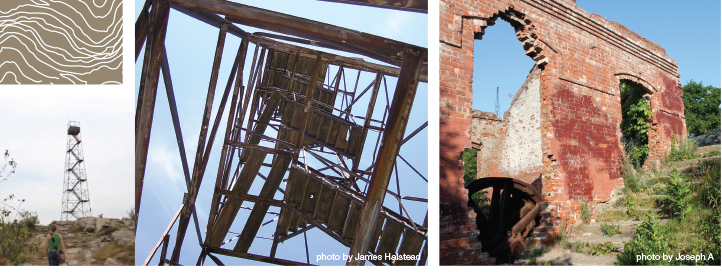
You are now truly blessed with some amazingly colorful views composed of the Hudson River, city of Beacon, city of Newburgh and even the Shawangunk and Catskill mountains. As the view's novelty begins to wear off you might ponder, “What was this concrete slab I am standing on?” The area actually has an interesting history. The site was home to the Beacon Casino and Beaconcrest Hotel, which opened in 1902. It was a popular tourist destination throughout the early 20th Century for New York City residents who came to escape the grueling city heat. Guests came to stay, dine, and dance at the famous resort. Unfortunately, in 1927 a fire broke out in the Beaconcrest Hotel, which subsequently spread to the Casino, leaving both structures destroyed. However, the Incline Railway was undamaged and a new casino was opened in 1928. After surviving several more fires, the Incline Railway closed in 1978 when the land in the area you are standing on was sold in a tax sale. In 1982 a fire destroyed the entire Incline Railway along with the rebuilt casino. When facing the river, you will notice a brick structure on your right. This is the remains of the Incline Railway's powerhouse. If you look closely you will also notice the old fly wheel that powered the two cable cars that rode the tracks below. Today, the Mount Beacon Incline Railway Restoration Society has bestowed the mission of rebuilding the railway, which was listed on the National Registrar of Historic places in 1982.

Although this is certainly one of the most beautiful views in the Hudson Valley, you should try to tear yourself away and continue up to the southern peak of Mount Beacon. When facing the river, if you turn around 180 degrees and look up to your right, you can actually see the fire tower off in the distance. This is where you are heading. It may seem a long way off with a great deal more climbing, but the good news is you have already completed the majority of the elevation on this hike.
You will continue to follow the well-defined trail up a gentle grade to the southeast. The trail is very wide in this section, and in a few spots there are some easily navigated ledges. Although the trail is well defined, it is not very well marked. This can cause some confusion because there are a few large unmarked trail junctions on the left that lead to a communication tower on the North Beacon peak. Though it is illegal to drive motorized vehicles here, many local residents routinely drive their jeeps and other ATVs in this area; this extra wear and tear on the trail further exacerbates the confusing trail system. As a rule of thumb on this section of trail, when in doubt, stay right. As you hike up to the fire tower, you will notice the remains of several vehicles on the side of the trail that never made it off the mountain.
After about a half mile, you will reach some small ledges, and the forest will open up around you. The trail then flattens out a bit as the colorful canopy begins to close in on you again. You should now watch out for the white trail on your right. Once again, this trail isn't marked very well, but your instinct will probably take over and force you in the right direction. Upon turning right on the white trail, it steeply rises on the final approach to the South Beacon summit. This is without a doubt the steepest section of trail you will face on the northeast side of Mount Beacon.
As you huff and puff your way up the slab rock face, the Beacon Fire Tower will come into view. When you reach the base, catch your breath as you take in the tremendous views that surround you. Then climb the steel stairs of the newly restored tower. The tower just had a grand re-opening ceremony in June of 2013. Once your soul has been immersed in the world of color and light, it is time to walk back down the way you came.
Watch the Video:
http://visitvortex.com/Hike_Mount_Beacon

Bonticou Crag
Difficulty: Moderate to Advanced
Total Mileage: 2.8
Elevation Gain: 849 feet
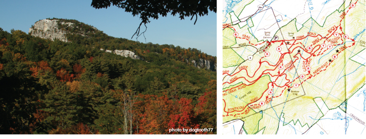
The Shawangunk Ridge has long been a favorite spot for leaf peeping. The flat-topped ridge opens up to scenic vistas in many locations. Perhaps one of its most quickly accessible and rewarding points is Bonticou Crag.
The best parking area to reach Bonticou Crag is located in the Mohonk Preserve at the Spring Farm Entrance off of Knolls Road in the town of New Paltz. Be advised there is a $12 day use fee for hikers, but children 12 and under are free; membership offers a cheaper option when using the Preserve regularly. The fees to explore Mohonk Preserve are well worth the investment and there are many areas to explore besides Bonticou Crag.
From the parking area, head up the Farm Road for a few hundred feet and then turn right onto the well-marked Bonticou Crag trail. The red trail will take you up the side of a nicely sloping meadow. It then crosses the Cedar Drive carriage road through a small grove of trees and almost immediately across another carriage road called Bonticou Road.
You then follow the red foot trail, as it gradually climbs a moderate grade for about .3 miles until it reaches a crossroads of Cedar Drive and Bonticou Road, which have looped back around you at this point. There is also a swampy area to your right. At this point you should veer to your left and follow a gravel carriage road up a slight grade. Do not follow Cedar Drive. After about a quarter mile, a steep rock outcrop will come into view, and you will walk parallel with it for around one hundred yards. This rock is actually Bonticou Crag, and you will have the opportunity to scramble up its steep face momentarily. But first, you will reach a junction with a yellow trail that descends to your left.
Follow the yellow trail until it reaches the base of Bonticou Crag, where you must weigh your options. If you are an experienced hiker and crave a good technical challenge, you will greatly enjoy the scramble that lays ahead of you on the yellow trail. However, if using your hands to pull yourself to the top of mountain is not your thing, you might want to follow the blue trail that leads to your left when facing Bonticou Crag. This trail eventually loops you back to the yellow trail on your right in a little over a quarter mile. After a relatively steep climb, the yellow trail takes you up to the top of the Crag on a more gradual grade. Here you will find your more adventurous friends laughing at you, errr, waiting for you.
If you are the adventurous sort and want to give yourself an upper body work out, you should continue on the yellow trail as it shimmies up the side of Bonticou Crag. The base of the Crag is filled with large boulders that you will need to scramble over to reach the top. Notice that the boulders have yellow blazes painted on them pointing you in the safest upward direction. Don’t lose track of the blazes and create your own path—the yellow-blazed path is definitely easiest. Soon, the boulders become larger, forcing you to use your hands to pull your body up. Eventually, the yellow trail culminates in a large crack, which you have to wedge yourself into and shimmy your way up. Be careful in this section, for there are plenty of places to lose your balance, and a bad fall could result in a serious injury. After forcing yourself up over this crack, the ascent is almost entirely behind you and the top of the dwarf pitch pine-lined Bonticou Crag comes into view. When you reach the pitch pines, turn right, head about 40 yards into the clearing, and enjoy the wonderful scenery. Count yourself blessed as you bask in the views that unfold before you. To the north, you can capture a compelling view of the Catskill's Eastern Devil's Path lined with a fiery mix of deciduous and coniferous trees. To your south, admire the Wallkill Valley at the end of harvest.
After you have soaked in the fruits of your labor, you can descend Bonticou Crag either via the scramble on the west side or the yellow trail to the blue trail on the north side to complete your loop and return to the Spring Farm parking area.
Watch the Videos:
http://www.visitvortex.com/Bonticou_Crag_Mohonk_Preserve_Hike
http://www.visitvortex.com/Hikes_Up_Bonticou_Crag_Mohonk_Preserve

Kaaterskill (High Peak)
Difficulty: Advanced
Total Mileage: 9-10 miles
Elevation Gain: 2,160
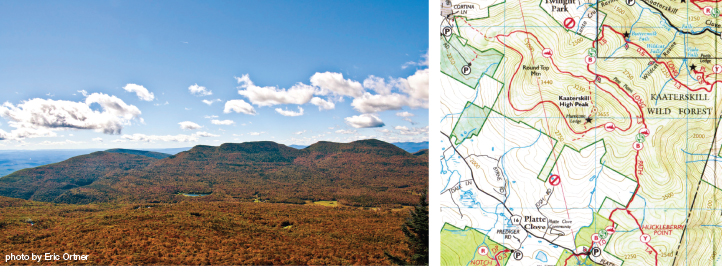
Perhaps some of the best leaf peeping in the Northeast can be found within the Blue Line of the Catskills. So, no hiking guide to fall foliage would be complete without including at least one Catskill 3500 foot peak. At 3,655 feet tall, Kaaterskill High Peak was once thought to be highest Catskill Mountain. Although this has been disproven, it still is a great hike and offers a wonderful opportunity for viewing fall foliage. Bagging High Peak involves bushwhacking because there is no marked trail to the summit. However, the peak is so popular that there is a well-established herd path traversing the mountain. This makes it possible to create a lollipop loop. Despite its popularity, this trail is not advised for most dogs or children. The trail can also get quite mucky during rainy seasons.
Kaaterskill's summit is most easily reached from the Devil's Kitchen parking area on the seasonal Platte Clove Road in West Saugerties. This is a popular parking area, so once again, it is advised that you arrive early to find a parking spot. The drive up Platte Clove Road can be an amazing opportunity for leaf peeping just on its own. From the Devil's Kitchen parking area, head north on the well-defined blue snowmobile trail. The trail follows a steady incline, eventually leading to a junction where you should keep right on the blue trail. After about a mile you will reach a yellow trail junction leading 1.4 miles to the scenic view of Huckleberry Point. As you continue on the blue trail, you will cross several streams through a boggy flat area. Be sure and try to keep your feet dry, as it can get quite wet here.
Once again the trail begins to steeply rise again. At 1.25 miles from the Huckleberry Point junction, there is an opportunity to shave some distance off of the hike by bushwhacking. If you have a GPS or are an experienced orienteer, head west when your reach the coordinates of "N42 09.561 W74 04.045". There may be a small cairn here, but don’t count on it. You should navigate to the coordinates of "N42 09.572 W74 04.235", where you will reconnect with the snowmobile trail.
Watch the Video:
http://visitvortex.com/Huckleberry_Point
If your backcountry orienteering skills are still unproven, then it is advised that you remain on the blue trail for another mile. Eventually you will reach a junction on your left. Follow this for a quarter mile until you reach a T in the trail. At the T, turn left, heading southeast. The trail in this section is relatively flat as you skirt along the edge of the final ascent of Kaaterskill High Peak. After about one mile, you will reach an interesting site. On the left side of the trail, you will notice the porcupine-eaten remains of a plane crash. This was a cargo plane that crashed in 1987, killing all passengers. If you orienteered to the coordinates listed previously, you will have reached the trail about 400 feet north of the site of the plane crash.
After you are finished examining the wreck, continue heading west on the well-defined snowmobile trail for just under three quarters of a mile. At this point, you will notice a large cairn marking the unofficial trail leading up to the summit of High Peak. The ascent is gradual at first, but quickly becomes quite steep. It culminates in a technical and challenging rock scramble up Hurricane Ledge. If you fall here, you could be seriously injured, so great caution is required. Once you have reached the top of Hurricane Ledge, you can rest. You are now blessed with a view of the Eastern Devil's Path and Platte Clove Valley. This is a great place to break for lunch and spend a good amount of time. Although you still need to reach the top of High Peak, rushing past this area will only cause disappointment, for there is no view at the actual summit of Kaaterskill High Peak because it is shrouded in coniferous trees.
After taking your well-deserved break, it is time to continue on to complete the summit. From Hurricane Ledge, the summit is only about another quarter mile away. Once you reach the small clearing at the top of Kaaterskill, keep your eyes open for the remains of a second plane that crashed nearby. There is not much to see at the apex of this 35er, so you'll quickly become bored. Once boredom has set in, follow the northern facing unmarked trail down to the main snowmobile trail again. This half mile stretch of unmarked trail is also very steep in sections, though not quite as exposed as Hurricane Ledge, so once again great caution is required. During heavy rain, the unmarked path can also seem more like a stream than a trail. Once you reach the official trail and are greeted by another large cairn, you should turn right. You will quickly come to another juncture and will need to turn right once more. This short trail will merge again onto the blue trail. At this merger, you are also required to turn right. From here, you will descend the blue snowmobile trail in a southeasterly direction to your car back the way you came. All the while, be sure to soak in the bountiful beauty that the Hudson Valley and Catskill Mountains have to offer.
See previous articles for more leaf peeping ideas:
visitvortex.com/magazine/17-Fun-Ways-To-Leaf-Peep
visitvortex.com/magazine/autumn2012-leafpeep

