Waterfalls mesmerize.
Their power and beauty make them some of nature’s most alluring wonders. And our region is blessed with an incredible array of water-falls, from gently rolling cascades to mammoth free-falling cataracts.

They are places for woodland adventures, for cooling off on hot summer days, and for quiet admiration of this amazing natural world. Between the Shawangunk Ridge and the Catskills, there are dozens of waterfalls, many with beautiful pools below them good for wading and swimming. Many are close to the road, some have easy, direct trails, and still others hide their secrets tenaciously, requiring steep scrambles and off-trail travel in order to enjoy them. No matter what level of adventure you are looking for, there are many options in the Hudson Valley.
The Shawangunks
High Falls (on Rondout Creek):
Located in the heart of the village of High Falls, this dramatic waterfall is easily seen from both the road and the bridge across the Rondout. It is approximately thirty feet tall and two hundred feet across. With the entire flow of the Rondout Creek pouring over the falls, this is easily the most powerful waterfall in the region. A hydroelectric turbine on the south side of the falls has harnessed this power, and while some fencing and an asphalt parking lot diminish the natural beauty of the spot, the ease of access and unique nature of the waterfall itself keep this a special place. The village of High Falls, with its shops, restaurants, pubs, and natural food co-op, is an easy walk from the public parking area adjacent to the waterfall and boat launch.
Parking & trail info: There is a large parking area a few hundred yards south of the intersection of County Route 213 and Lucas Avenue in High Falls. Look for the lot just off the east side of the road downstream of the steel bridge. The parking area is easily seen from the road, as is the waterfall itself. Follow the path to the base of the falls.
Awosting & Peterskill Falls:
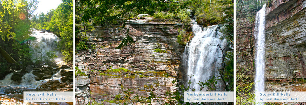
Formed by the upper portion of the Peterskill (kill is a Dutch word for creek or stream and is common throughout the Hudson Valley region) is one of the easiest to reach and most beautiful waterfalls in the region. After parking just inside the main entrance of Minnewaska State Park Preserve, a fifteen-minute stroll on carriage roads leads down to the stunning sixty-foot Awosting waterfall. A large and crystal clear pool is below the falls and tucked into a half-moon line of quartz cliff. The open area, beautiful cliffs, and shimmering spray of the falls make this area a must-see. Unfortunately, the park does not allow swimming, but it is not uncommon to see people soaking their feet and kids splashing around a bit. Peterskill Falls is a short walk further downstream. During the mid 1800’s, this roadside spot was the site of a sawmill operated by George Davis, who eventually orchestrated the sale of hundreds of acres of land, including Lake Minnewaska itself, to Alfred Smiley. Peterskill Falls is a more rugged area and not ideal for smaller children.
Parking & trail info: Park in the lower lot on the right, just past the fee station/entrance for Minnewaska State Park Preserve on the west side of route 44/55. Walk back toward the fee station, turn right onto the entrance road, and then turn left onto the carriage road, which will take you down to the falls. Continue onto the more rugged Peterskill Falls a few hundred yards down the carriage path.
Sheldon Falls:
The Peterskill weaves a rugged path down to the Rondout Creek in Accord. Along that path, it has carved its way down to bedrock in many places, leaving the stream flowing over smooth rock slabs and a series of lovely cascades historically known as Sheldon Falls. This area more than makes up for its lack of height with a series of deep pools set in a beautiful forest. It is an isolated yet totally accessible area.
Parking & trail info: Park at the Peterskill entrance of Minnewaska State Park Preserve. There is a day-use fee. The trailhead is at the west end of the lot (far right corner if you are facing the road). Look for a red-blazed foot path past the rock-climbing area that is clearly marked for climber’s use only. Follow the path downstream (right) for approximately 1.5 miles to a foot bridge that crosses the creek. Do not cross here, but rather continue downstream on an obvious trail to the series of low waterfalls another hundred yards away. Note that there are a number of other paths in this area. Purchasing a map of the area is always a good plan before heading out in a new place. Stay along the creek, and you can’t get lost.

Stony Kill Falls:
This fifty-foot-tall waterfall has a relatively short and flat approach. This trail also links to the Minnewaska State Park network of trails and traverses one of its less congested areas. There is a small pool at the base of the falls that shrinks dramatically over the course of the warm summer weather. A beautiful pool lies above the falls and lasts long after the lower pool has largely dried up. Follow the steep path around the left side of the cliff to reach the upper pool.
Parking & trail info: From the main entrance of Minnewaska State Park Preserve, go west on 44/55 4.5 miles, turn left onto Minnewaska Trail, and then make an immediate left onto Rock Haven Road. In two miles, go left onto Shaft 2A, follow to gate that blocks the road, and park in pullout. Walk past the gate and follow gravel road past a shale pit and onto a foot path that leads to the falls in several hundred yards. It's a bit of a hike in, with some rock scrambles along the way. Be prepared.
Rainbow Falls:
This ethereal beauty is across a lovely ravine from a popular carriage road that leads to Awosting Lake. In drier months, Rainbow Falls slows to a trickle, but even at low water times of the year, this is a special spot with hanging gardens, deep green mosses, and birds’ nests tucked up into the nooks and crannies of the seventy-foot overhanging cliff. It is an approximately 2.5 mile hike to Rainbow Falls on fairly rugged forest paths.
Parking & trail info: Park in the upper lot at the main entrance at Minnewaska State Park Preserve. Follow the Awosting Carriage Road past the swim area on the north side (right looking at lake from the parking lot) for approximately three miles, (passing the junction with Blueberry Run trail) to the Rainbow Falls Trail. The falls can be seen across a ravine to the north. Go north (right) on RFT and follow it steeply downhill, across the ravine, and then back up to right to the falls.
Verkeerderkill Falls:
An isolated waterfall that is rarely visited, Verkeeerderkill Falls (say that five times fast!) is one of the real prizes of this group. It is the tallest waterfall in the region and is set in a spectacular, isolated spot. For most people, a trip out to Verkeerderkill Falls will take much of the day, especially if it includes a visit to the series of deep clefts and crevices in the quartz conglomerate cliffs known as the ice caves. The falls themselves are best viewed from below, so a steep scramble on an unmaintained trail must be done to really make the most of a visit to this hundred-foot-plus cascade.
Parking & trail info: From the center of Ellenville, turn left onto Route 52. Go approximately 4 miles. Look for a green sign for Cragsmoor pointing to the right. Shortly after the sign, make a right on Cragsmoor Road. Go one mile to the Cragsmoor post office, and turn right. Go a short distance, and make another right onto Sam's Point Road; follow for approximately 1 3/4 mile to the entrance of the Preserve. Arrive early because the parking lot fills up quickly, and be sure to pay the $10 parking fee.
Split Rock:
This narrow, twenty-foot deep slot is a geological wonder and a true gem of the Shawangunk region. A nice waterfall and a twenty-foot wide by one hundred fifty-foot long chest-deep pool make this one of the single most popular spots on the Mohonk Preserve. A two-minute approach from the parking area ensures that you will rarely enjoy this place alone, yet still the remarkable nature of the place makes it well worth sharing.
Parking & trail info: Find Clove Valley Road three miles west of the Mohonk Preserve Visitors Center on route 44/55. Follow Clove Valley for a mile and a half to entrance to parking lot on left. Note that the Mohonk Preserve requires either a membership or a day-use fee from visitors. Split Rock is just across the road from the parking lot.

The Catskills
Kaaterskill Falls:
Perhaps the most popular and certainly the most dramatic waterfall in the region, Kaaterskill Falls is the tallest waterfall in New York at 180 feet. This is a dramatic place. The trail follows along the tumbling Kaaterskill Creek, leading up to a lower waterfall that is about thirty feet tall and in warmer years slows to a trickle. A huge double-tiered brownstone amphitheater hangs above the lower falls and can be reached by a spidery network of social paths on either side of the creek. Though not too difficult, caution should be taken in this area as accidents happen every year and some spots along the way are extremely exposed. The amazing main waterfall is at the back of the ampitheater and crashes one hundred eighty feet into a gorgeous pool that is quite a popular swim hole during the hotter weather. Careful scrambling takes the intrepid few up behind the waterfall’s spray.
Parking & trail info: From route 23A in Palenville, head west up into Kaaterskill Clove. Approximately 2.5 miles up 23A from the first bridge over Kaaterkill Creek the road takes a sharp left turn, and there is an obvious trailhead on the right. Continue uphill a short distance, and park in a large paved lot on the left. Walk back to the trailhead (be careful on the narrow, typically busy road), and follow the well- worn trail up to the falls. It is a short but steep hike to this magnificent waterfall.

Plattekill Falls:
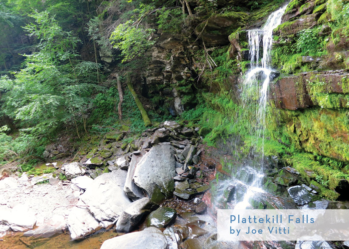
The Platte Clove has been called the Grand Canyon of the East. While this comparison might be a bit of a stretch, the area does have some of the most dramatic terrain in the Catskills. Indian Head, Haystack, and High Peak are just a few of the mountains densely packed around the Platte Clove, all making for some really rugged terrain. The Platte tumbles steeply from these lofty peaks over at least ten distinct waterfalls. At the top of the ravine is Plattekill Falls, a gorgeous forty- foot high fall with a large chest-deep, icy-cold pool. The steep sandstone cliffs around the falls are home to a wild tangle of vines and hanging gardens of ferns, mosses, and wildflowers.
Parking & trail info: Find the junction of route 23A and route 16 (Railroad Ave) in Tannersville. Follow 16 until it merges with Plattekill Road, and follow it for approximately six miles to the Huckleberry Ledges/High Peak trailhead on the left (if you reach a large pullout and sign saying you have reached the section of road not maintained in winter, you have just passed the trailhead parking lot). Walk back the way you came in from the parking area, and go right up the short hill to a small red artist’s cabin on the left. Follow a path that angles steeply downhill between the cabin and the road. The waterfall and glorious swim hole are at the bottom of the path.

Bridal Veil Falls:
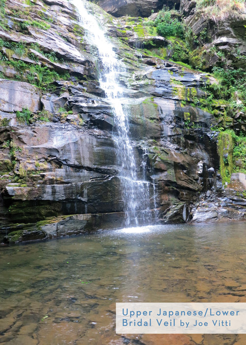
Significant caution must be taken when visiting this area, as rescue would be quite challenging and slow coming. That said, it’s a great adventure getting down to the base of Bridal Veil. The waterfall is 60 feet high and crashes down onto a mad jumble of boulders, filling the air with mist and spray and the narrow ravine with a cacophony of sound. A small pool forms when water levels are high. Though not far from the car if you are a bird, Bridal Veil must be earned with a fair amount of rock scrambling and a couple of spots where a fall would be quite costly.
Parking & trail info: Park as if going to Plattekill Falls, but instead walk left onto the Platte Clove Road and immediately find a small trail that drops steeply down just before the old stone bridge. Use extreme caution scrambling down into the steep side ravine below; it is known as the Devil’s Kitchen. Follow the ravine and small creek downhill with vertical rock walls on both sides. At the bottom of the ravine, look for a narrow path on the right that wraps around and down into the larger Plattekill Ravine. The spectacular Bridal Veil is above you on the right. Note that below the spot where The Devil’s Kitchen meets the Plattekill drainage there are many more waterfalls, as well as some truly amazing swim holes. Unfortunately, it is quite challenging to get around the multiple cliff faces that guard the way. One solution is to bring climbing harnesses and a rope and rappel over the cliffs to continue to explore. From the bottom of the Platte Clove Road, there’s a trail that leads down to the creek and then up the ravine, passing several stunning waterfalls and swim holes. The problem is that the area is adjacent to significant private property and parking is a real challenge.
Best Advice: Park somewhere else, and ride your bike!
Take precautions along paths as erosion and water can create slick conditions. As a general rule, use common sense and be aware of the loose rocks, dirt and water-slick stones as some spots can be dangerous or deadly if not careful.
Cheers!
Remember to LEAVE NO TRACE, and enjoy the adventures!
Save

